Business Details
25 Years
experience
Professional Land Surveying Services in Newport News, VA
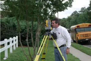
At Michael Surveying & Mapping, we have dedicated ourselves to delivering precise and reliable land surveying solutions since 2001. Our team of professionals brings over 60 years of combined experience, ensuring every project benefits from deep expertise and a commitment to excellence. We specialize in a comprehensive range of services, including boundary surveys, topographic mapping, and hydrographic studies, tailored to meet the unique needs of architects, engineers, municipalities, and private clients. Utilizing cutting-edge technology such as GPS and 3-D laser scanning, we maintain rigorous standards of accuracy and efficiency. Headquartered in Newport News, Virginia, our firm operates under the direct supervision of licensed surveyors in Virginia and North Carolina, reinforcing our dedication to compliance and quality.We pride ourselves on fostering long-term client relationships through proactive communication and solutions that anticipate future challenges. As members of prestigious industry organizations like the American Congress on Surveying and Mapping, we remain at the forefront of advancements in our field. Our mission is simple: to combine technical precision with unwavering integrity, ensuring every client receives value-driven service that meets the highest professional standards.

Services
Boundary Surveys
Topographic Mapping
Hydrographic Surveys
GIS Surveying
Construction Surveys
ALTA/ACSM Surveys
Underground Utility Mapping
Digital Terrain Modeling
Details
- Year established: 2001
Highlights and features
- Our team has over 60 years of combined experience in land surveying
- All projects supervised by Virginia and North Carolina licensed surveyors
- Utilize advanced GPS and 3-D laser scanning technology for accuracy
- Maintain active memberships in leading surveying organizations
- Proven track record serving architects, engineers, and municipalities
Services
Boundary Surveys
We conduct precise boundary surveys to define property lines using advanced GPS technology and historical records. Our licensed surveyors ensure compliance with Virginia and North Carolina regulations while resolving disputes and supporting real estate transactions. Clients receive detailed documentation for legal and development purposes.
Topographic Mapping
Our topographic surveys capture natural and man-made features to create accurate elevation models. This data supports construction planning, environmental assessments, and infrastructure projects. We use 3-D laser scanning to deliver high-resolution maps for engineering and design teams.
Hydrographic Surveys
We specialize in hydrographic surveys for coastal, riverine, and inland water projects. Our methods assess shoreline changes, flood risks, and underwater infrastructure conditions. Clients rely on our data for FEMA certifications, dredging projects, and environmental compliance in Virginia and North Carolina.
Construction Surveys
Our construction surveys provide layout and monitoring services for building foundations, utilities, and roadways. We ensure alignment with design plans through stakeout and as-built documentation. Clients benefit from reduced rework and adherence to project timelines across commercial and municipal developments.
GIS Surveying
We integrate GIS technology to create spatial data layers for land management and urban planning. Our mapping solutions support utility networks, environmental studies, and asset management systems. Clients receive actionable insights through digital terrain models and geodetic control networks.
People
Paul W. Michael, Jr.
President
Paul W. Michael, Jr. leads the firm with over 20 years of experience in land surveying. Licensed in Virginia and North Carolina, he specializes in boundary resolution and construction support. His leadership emphasizes technical excellence and client-focused solutions.
Questions
What types of surveying services do you offer?
We provide boundary surveys, topographic mapping, hydrographic studies, construction layout, GIS services, and ALTA/ACSM land title surveys using advanced technology.
Are your surveyors licensed in Virginia and North Carolina?
Yes, all projects are supervised by licensed professional surveyors in both Virginia and North Carolina to ensure regulatory compliance.
How do you handle complex land development projects?
We collaborate with engineers and architects to deliver precise data for site planning, utility design, and environmental assessments throughout the development process.
Can you perform emergency surveying services?
While we prioritize scheduled projects, we accommodate urgent requests for boundary disputes and construction delays on a case-by-case basis.
Do you work with residential and commercial clients?
Yes, we serve both residential property owners and commercial developers for land transactions, subdivisions, and infrastructure projects.