Business Details
50+ Years
experience
Your Trusted Land Surveying Partner in Santa Rosa
Founded in 1954 as Passarino Associates, Cinquini & Passarino has built a legacy of excellence in land surveying across the Bay Area. Our firm specializes in comprehensive surveying solutions, including boundary surveys, topographic mapping, and geodetic control networks, serving developers, contractors, engineers, and government agencies. With dedicated GIS and hydrography departments, we leverage cutting-edge technology to deliver surveys of the highest accuracy. Our team of licensed professionals brings decades of combined experience to every project, ensuring reliable results for residential, commercial, and infrastructure developments. We maintain a strong commitment to client satisfaction, offering tailored services that address unique project challenges.Over 70 years of operation, we have established ourselves as a trusted partner for precision surveying and data-driven geospatial solutions. Our multi-office presence in Santa Rosa, Healdsburg, Napa, and Oakland enables us to serve clients efficiently across Northern California. By integrating advanced methodologies with deep industry knowledge, we help clients minimize delays and achieve successful project outcomes. Our expertise extends to specialized services like bathymetric surveys, wetland delineation, and expert witness testimony, reflecting our versatility in addressing complex surveying needs.
Services
Land Surveying
Railroad Surveying
Construction Staking
Hydrography
GIS Mapping
Details
- Year established: 1954
Highlights and features
- We offer 70 years of experience in professional land surveying.
- Our team utilizes the latest surveying equipment for unmatched accuracy.
- We provide dedicated GIS and hydrography departments for specialized needs.
- Our services support developers, contractors, and government agencies.
- We operate multiple offices across Northern California for local accessibility.
Services
Land Surveying
Our land surveying services provide precise boundary determinations and topographic mapping for property development. We deliver accurate legal descriptions and ALTA surveys to support real estate transactions and construction projects. Clients benefit from our expertise in resolving boundary disputes and ensuring compliance with local regulations.
Railroad Surveying
Specializing in railroad surveying, we offer right-of-way mapping and alignment verification for rail systems. Our team supports maintenance and expansion projects with detailed data on track geometry and infrastructure. Clients rely on our precision to ensure safety and regulatory compliance for freight and passenger rail operations.
Construction Staking
We provide construction staking services to guide accurate site development for residential, commercial, and infrastructure projects. Our surveyors establish precise reference points for grading, utilities, and structures. Clients minimize delays by using our data to align equipment and materials correctly during construction.
Hydrography
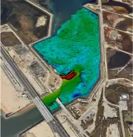
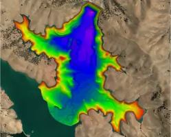
Our hydrographic surveys map underwater terrain for reservoirs, harbors, and wetlands using multibeam sonar technology. We support dredging projects and environmental monitoring with bathymetric data. Clients use our results to manage coastal erosion, habitat restoration, and navigational safety.
GIS Mapping
We develop GIS mapping solutions that integrate spatial data for land management and infrastructure planning. Our analysts create interactive web maps and 3D visualizations for municipal and environmental projects. Clients access accurate, up-to-date information to support decision-making and regulatory reporting.
People
James M. Dickey
Principal
James M. Dickey is a licensed Professional Land Surveyor with decades of experience in boundary determination and construction staking. He oversees project accuracy and client coordination.
Anthony G. Cinquini
Principal
Anthony G. Cinquini, a licensed engineer and surveyor, leads technical operations and quality control for complex surveying projects across Northern California.
Mark P. Andrilla
Managing Project Surveyor
Mark P. Andrilla manages large-scale land development surveys, ensuring compliance with municipal and state regulations for residential and commercial clients.
Derek J. Clark
Professional Land Surveyor
Derek J. Clark specializes in boundary surveys and legal descriptions, providing expert testimony for property disputes and title resolution.
Jimmy R. Kulpa
Chief Hydrographer
Jimmy R. Kulpa leads hydrographic survey teams, utilizing multibeam sonar for underwater mapping projects in coastal and inland waterways.
Questions
What services does Cinquini & Passarino offer?
We specialize in land surveying, railroad surveying, construction staking, hydrography, and GIS mapping for developers, engineers, and government agencies.
How long has the company been in business?
Founded in 1954 as Passarino Associates, we have over 70 years of experience in professional land surveying.
Which areas do you serve?
We operate in Santa Rosa, Healdsburg, Napa, Oakland, and surrounding regions of Northern California.
What technology do you use for surveys?
We employ advanced tools like multibeam sonar, LiDAR, and GPS systems for precise data collection.
What project types do you handle?
Our expertise includes residential subdivisions, infrastructure projects, environmental assessments, and complex commercial developments.