Business Details
43 Years
experience
Your Trusted Land Surveying Experts in Florida
Accurate Land Surveyors has provided professional land surveying services in Florida since 1983. With over 100,000 completed surveys, we serve Miami-Dade, Broward, Palm Beach, Martin, and St. Lucie counties. Our team of licensed professionals combines advanced technology with decades of experience to deliver precise, timely results. We specialize in boundary surveys, subdivision plats, construction layout, and FEMA elevation certificates. Our commitment to excellence is demonstrated through our state-of-the-art equipment, proprietary software, and 72-hour turnaround guarantee. As members of the Florida Society of Professional Land Surveyors, we maintain the highest industry standards.Our president, Robert L. Thompson, established the company after serving as Port Everglades Surveyor and Broward County Surveyor. We offer free seminars for real estate professionals and collaborate closely with attorneys, title companies, and construction firms. Our radio-dispatched field crews use electronic total stations and data collectors for maximum efficiency. With 30+ years of continuous service, we've built lasting relationships through accurate documentation and client-focused solutions. Our work supports property transactions, development projects, and legal boundary determinations across South Florida.

Services
Boundary Survey
Location Survey
Subdivision Survey
FEMA Elevation Certificate
Topographic Survey
Construction Layout
Hydrographic Survey
Property Dispute Survey
Details
- Year established: 1983
Highlights and features
- 30+ years of continuous service in South Florida
- Completed over 100,000 land surveys
- Licensed by Florida's Department of Professional Regulation
- 72-hour turnaround guarantee on all projects
- Serving 5 South Florida counties since 1983
Associations and certifications
- Department of Professional Regulation
- Florida Society of Professional Land Surveyors
What people say
Always accurate
Speedy service
Seasoned professionals
Excellent cooperation
Best in tri-county
Services
Boundary Survey
Our boundary surveys precisely define property lines using iron rod markers and digital mapping. This service helps prevent encroachments during fence installation, pool construction, or property development. Our licensed surveyors verify historical records and use GPS technology to ensure 99.9% accuracy for legal documentation and real estate transactions.
FEMA Elevation Certificate
We provide official FEMA elevation certificates for flood insurance requirements. Our surveyors use robotic total stations to measure building elevations against base flood levels. This documentation helps property owners secure accurate insurance rates and supports flood map appeals through the National Flood Insurance Program.
Topographic Survey
Our topographic surveys map natural and man-made features including elevations, utilities, and vegetation. This data supports architectural planning and infrastructure development. We combine aerial photography with ground measurements to create detailed contour maps for construction and zoning permit applications.
Construction Layout
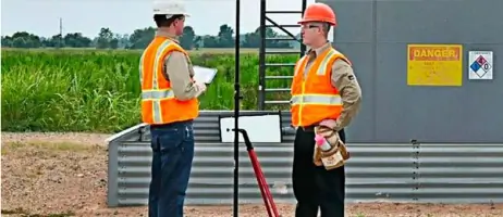
We provide precise stakeout services for new construction projects. Our team marks building corners, utility lines, and grading elevations using GPS and total station technology. This ensures proper alignment with approved plans and local building codes during residential and commercial development.
Subdivision Survey
Our subdivision surveys divide large parcels into smaller lots with precise measurements. We design roadways, drainage systems, and utility easements while ensuring compliance with municipal regulations. Final plats are recorded with county officials for legal property transfers and development projects.
People
Robert L. Thompson
President
Founder with 30+ years of experience, former Port Everglades Surveyor and Broward County Surveyor. Licensed professional surveyor who established Accurate Land Surveyors in 1983. Maintains industry leadership through technology innovation and client-focused solutions.
Questions
What types of surveys do you offer?
We provide boundary surveys, FEMA elevation certificates, topographic surveys, construction layout, subdivision plats, hydrographic surveys, and property dispute resolution services.
How quickly can you complete a survey?
Our standard turnaround time is 72 hours from order placement, with expedited options available for urgent projects.
Are your surveyors licensed?
All our surveyors are licensed by Florida's Department of Professional Regulation and maintain active memberships in professional associations.
Do you serve areas outside South Florida?
While our primary service area includes Miami-Dade, Broward, Palm Beach, Martin, and St. Lucie counties, we consider special projects in other Florida regions.
How do you handle property disputes?
We conduct precise boundary surveys using historical records and modern technology to establish legal property lines and resolve neighbor disputes.
Can you work with title companies?
We provide full cooperation with title company processors and examiners, including document verification and legal description reviews.