
Business Details
44 Years
experience
Your Trusted Land Surveying Experts in Abilene, TX
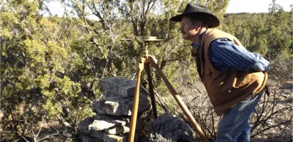
Sheppard Surveying, founded in 1982 by Maxey Sheppard, a Registered Professional Land Surveyor and Licensed State Land Surveyor, has dedicated over four decades to delivering precise land surveying services across Texas. Our expertise spans boundary surveys, route surveys, control surveys, and specialized projects for oil & gas, wind energy, and FEMA flood elevation data. We combine advanced technology like GPS and CAD with traditional methods to ensure accuracy while maintaining a deep understanding of Texas land laws.Our team prioritizes thorough research, field verification, and clear communication to produce defendable surveys that meet legal and engineering standards. With a focus on client collaboration, we tailor solutions for unique projects while adhering to strict professional ethics and technical excellence.
Services
Boundary Surveys
Route Surveys
Control Surveys
Oil & Gas Surveys
Wind Energy Surveys
FEMA Flood Data
Preliminary Engineering
Details
- Year established: 1982
Highlights and features
- We offer 40+ years of experience in Texas land surveying and legal boundary determination
- Our team uses advanced GPS and CAD technology while maintaining traditional surveying principles
- We provide detailed research and courthouse record analysis for legally defensible surveys
- Specialized expertise in oil & gas, wind energy, and FEMA flood elevation projects
- Comprehensive service from initial research to final plat delivery with no hidden costs
Services
Boundary Surveys
We conduct comprehensive boundary surveys to determine property lines using legal records, field measurements, and Texas land laws. Our process includes courthouse research, monument location, and GPS verification to ensure legally defensible results. Clients receive detailed plats and metes-and-bounds descriptions for property transactions or disputes.
Route Surveys
Our route surveys establish easements for pipelines, power lines, and transportation corridors. We combine field measurements with legal documentation to create accurate alignment plans. This service supports infrastructure projects across multiple Texas counties with precise location data for construction and regulatory compliance.
Control Surveys
We establish horizontal and vertical control networks for large-scale engineering projects. These surveys provide foundational data for construction projects, monitoring systems, and aerial mapping. Our work supports long-term infrastructure developments like dams, airports, and transportation corridors with millimeter-level precision.
Oil & Gas Surveys
We provide specialized surveying for oil and gas operations including well locations, unit boundaries, and pipeline routes. Our team works with geologists to identify abandoned wells and ensure regulatory compliance. Services include staking, plats, and boundary verification for exploration and production sites across Texas.
Wind Energy Surveys
Our wind energy surveys combine boundary, topographic, and construction staking services for large-scale renewable projects. We deliver ALTA-certified surveys ensuring title clarity and boundary compliance. This service includes control networks, site mapping, and documentation for financing and insurance requirements.
People
Maxey Sheppard
President
Registered Professional Land Surveyor since 1980 with 50+ years of experience. Served as Texas Society of Professional Surveyors President and developed continuing education programs. Specializes in legal boundary determination and Texas land law interpretation.
Monte Sheppard
Party Chief
Field operations manager with 20+ years of experience. Certified Level II Survey Technician with expertise in GPS systems, digital leveling, and boundary retracement. Handles all field operations and technical training for Sheppard Surveying's projects.
Questions
What services does Sheppard Surveying offer?
We provide boundary surveys, route surveys, control surveys, oil & gas surveys, wind energy projects, and FEMA flood elevation data services across Texas.
How long has Sheppard Surveying been in business?
We've been providing professional land surveying services since 1982, with over 40 years of combined experience from our team members.
What areas do you serve?
Our primary service area includes Abilene, Foard County, Callahan County, and surrounding regions throughout Texas.
What makes your boundary surveys different?
We combine advanced GPS technology with traditional methods and thorough legal research to produce defendable, accurate boundary determinations that meet Texas land law requirements.
Do you handle complex surveying projects?
Yes, we specialize in challenging projects including ALTA surveys, energy sector developments, and large-scale infrastructure projects requiring precise control networks.
How do you ensure survey accuracy?
We use modern GPS equipment, perform multiple field verifications, and conduct mathematical checks on all measurements before finalizing any survey documentation.