
Business Details
Expert Surveying Services in Clearwater, FL
Polaris Associates has established itself as a trusted leader in professional surveying services, combining decades of field expertise with cutting-edge technology. Our team of certified survey technicians and licensed professionals delivers precise site data solutions tailored to meet the demands of land development, infrastructure projects, and environmental assessments. With contracts spanning municipal governments, educational institutions, and private developers across Florida, we maintain a steadfast commitment to accuracy, timeliness, and client satisfaction. Our investment in state-of-the-art GPS equipment and digital data processing systems ensures reliable results for complex projects.Backed by comprehensive insurance coverage and industry certifications, we prioritize continuous education for our staff to maintain technical excellence. Our Clearwater headquarters provides strategic access to serve multiple counties, while our collaborative approach ensures clients receive actionable insights from raw survey data. For over three decades, our president's hands-on experience in boundary mapping, wet zone surveys, and transportation projects has shaped our reputation for solving challenging geospatial problems. We maintain transparent communication throughout every project phase, from initial control mapping to final CAD deliverables.
Services
Coordinate Control Maps
Utility As-Builts
ALTA/ACSM Land Title Surveys
Wet Zone Surveys
Eminent Domain Mapping
Photogrammetric Control
Boundary Topography
Global Positioning System (GPS)
Flood Zone Determination
Tree Locations Mapping
Highlights and features
- We have 36 years of field surveying experience with Florida licensed professionals
- Our team includes Certified Survey Technicians (CST) through NSPS
- We maintain contracts with multiple Florida municipalities and county departments
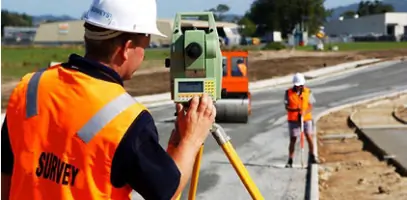
- We utilize robotic total stations and survey-grade GPS equipment
- Our staff holds leadership roles in the Florida Survey and Mapping Society
Associations and certifications
- National Society of Professional Surveyors (NSPS)
Services
Hydrographic Surveys
Our hydrographic surveying services map underwater terrain for coastal engineering and floodplain management. Using specialized GPS equipment and sonar technology, we collect precise bathymetric data for port developments and environmental assessments. This critical information supports infrastructure planning while maintaining compliance with regulatory requirements for waterway projects.
GPS Mapping
We utilize survey-grade GPS systems for high-accuracy positioning in land development and transportation projects. Our GPS mapping services establish precise control networks for construction layout and boundary determination. This technology enables efficient data collection across large areas while maintaining compatibility with digital CAD workflows for seamless project integration.
Wet Zone Surveys
Our wet zone surveying expertise identifies jurisdictional wetland boundaries for land development projects. We combine field measurements with regulatory requirements to define protected areas while supporting environmental compliance. This specialized service helps clients navigate permitting processes through accurate mapping of sensitive ecological zones.
ALTA Surveys
We conduct ALTA/ACSM land title surveys meeting national standards for commercial property transactions. Our comprehensive boundary analysis includes easement identification and encroachment verification. These detailed surveys provide lenders and title companies with accurate representations of property rights and physical improvements for risk assessment.
Construction Layout
Our construction layout services establish precise reference points for building and infrastructure projects. Using robotic total stations and digital data collection, we ensure accurate implementation of design plans. This critical service supports grading, foundation placement, and utility installation while maintaining compliance with municipal specifications throughout the development process.
People
Dan H. Rizzuto
President
President with 36 years surveying experience and 25 years as Florida licensed surveyor. Holds associate degree from St. Petersburg College. Specializes in GPS control mapping for transportation projects and private land development. Leads team with 19 years at Polaris.
Justin Ferrans
Vice President
Vice President with 20 years experience in field and office surveying. Holds bachelor's degree from University of South Florida. Active in Florida Survey and Mapping Society leadership. Manages technical operations and client relations for Tampa Bay projects.
Jenny Thomas
Senior CAD Technician
Senior CAD Technician with specialized expertise in transforming field data into digital deliverables. Certified Survey Technician (CST) through NSPS. Supports complex land development projects through precise coordinate geometry and CAD modeling.
Bob Dye
Senior CAD Technician
Senior CAD Technician responsible for processing survey data into actionable digital formats. Maintains CST certification through NSPS. Specializes in converting raw field measurements into construction-ready plans using advanced software systems.
Questions
What surveying services do you offer?
We provide hydrographic surveys, GPS mapping, ALTA/ACSM land title surveys, wet zone surveys, construction layout, boundary topography, and flood zone determination services.
Which areas do you service?
We serve Pinellas, Pasco, Hillsborough, Manatee, Hernando, Polk, and Sarasota counties from our Clearwater headquarters.
Are your technicians certified?
All field crew chiefs and office technicians hold Certified Survey Technician (CST) credentials through the National Society of Professional Surveyors.
How do you ensure survey accuracy?
We use robotic total stations and survey-grade GPS equipment combined with digital data processing systems to maintain precision across all projects.
Can you handle government contracts?
Yes, we maintain active contracts with the City of Largo, City of Dunedin, Hillsborough County Stormwater Department, and Port of Tampa.