Business Details
30 Years
experience
Your Trusted Land Surveying Partner in Greensboro
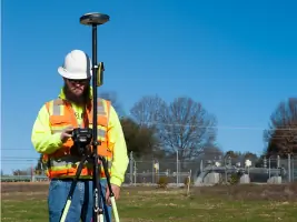
Regional Land Surveyors has been a trusted partner in land surveying since 1996, combining traditional expertise with cutting-edge technology. Our team of six Professional Land Surveyors and 12 field crews utilizes GPS, 3D laser scanning, and drones to deliver precise data across residential, commercial, energy, and governmental markets. With over 85 years of combined experience, we operate in North Carolina, South Carolina, Virginia, California, Colorado, and Wyoming. Our services include ALTA/NSPS surveys, environmental assessments, and construction stakeouts, supported by nine CAD technicians. We maintain rigorous standards through state-specific licenses and affiliations with professional societies.Our leadership team brings decades of technical expertise and industry recognition, including board membership in the Home Builders Association of Winston-Salem. Clients benefit from our non-traditional capabilities while relying on our foundational surveying excellence. We serve diverse projects from historic preservation to renewable energy developments. Our commitment to accuracy has made us one of the largest independent surveying firms in the mid-Atlantic region. This combination of experience, technology, and specialized services positions us as a comprehensive solution for complex surveying needs.

Services
Commercial Surveys
Topographic Surveys
ALTA/NSPS Surveys
3D Laser Scanning
GPS Surveys
Environmental Surveys
Pipeline Surveys
Construction Surveys
Expert Witness Services
Details
- Year established: 1996
Highlights and features
- We offer 30+ years of combined leadership experience in land surveying
- Our team utilizes GPS, 3D laser scanning, and drone technology
- Licensed in six states including North Carolina and California
- Six Professional Land Surveyors and 12 field crews available
- Specialized expertise in energy, environmental, and governmental markets
Services
Commercial Surveys
Our commercial surveys provide precise boundary and topographic data for site development and property transactions. We deliver detailed mapping and documentation to support commercial construction projects. Clients receive accurate measurements that meet all regulatory requirements for business property development.
Topographic Surveys
We create detailed topographic maps showing natural and man-made features with elevation data. Our surveys include contour lines, vegetation, and water bodies for comprehensive land analysis. This information supports engineering designs and environmental assessments across various project types.
ALTA/NSPS Surveys
Our ALTA/NSPS surveys meet national standards for property transactions and title insurance requirements. We document boundary details, easements, and improvements with exceptional precision. Clients receive comprehensive reports that satisfy lenders and title companies during commercial property transfers.
3D Laser Scanning
We use 3D laser scanning to capture precise measurements of complex structures and terrain. This technology creates detailed digital models for construction and preservation projects. Clients benefit from faster data collection and enhanced visualization of project sites.
Pipeline Surveys
Our pipeline surveys support oil and gas projects with route planning and construction documentation. We provide precise mapping that meets PHMSA standards for pipeline installation. Clients receive accurate data for permitting, design, and environmental compliance throughout the project lifecycle.
People
Kim R. Lilly
President and Senior Project Manager
Kim R. Lilly leads daily operations and manages commercial and residential projects. With 25+ years of experience, he holds multiple state surveyor licenses and serves on the HBAWS board. He graduated from West Virginia University Institute of Technology in 1985.
David A. Clark
Vice President and Senior Project Manager
David A. Clark oversees field operations and specializes in oil and gas projects. A registered surveyor since 1998, he brings expertise in commercial and residential surveying. He graduated from Guilford Technical Community College with surveying and CAD certifications.
Jeffery S. Smith
Project Manager
Jeffery S. Smith manages GIS operations and client relationships. With a Master's in geospatial information science from NC State, he combines technical expertise with practical surveying experience. He holds surveyor licenses in multiple states and contributes to professional societies.
Questions
What surveying services do you offer?
We provide commercial/residential surveys, ALTA/NSPS surveys, 3D laser scanning, pipeline surveys, and environmental assessments using GPS and drone technology.
Which states do you serve?
We operate in North Carolina, South Carolina, Virginia, California, Colorado, and Wyoming with licensed professionals in each state.
What makes your company different?
We combine traditional surveying with advanced technology like 3D scanning and drones while maintaining our focus as an independent surveying firm.
How experienced is your team?
Our team includes six Professional Land Surveyors and 12 field crews with over 85 combined years of experience in the industry.
Can you handle complex projects?
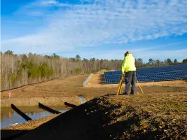
Yes, we've completed projects for educational institutions, solar farms, and natural gas pipelines using specialized surveying techniques.
How do I request a survey?
Contact us at (336) 665-8155 or through our website to discuss your project requirements with our surveying professionals.