Business Details
21 Years
experience
Professional Land Surveying Services in Greensboro, NC
Sacks Surveying & Mapping was established in 2005 in Greensboro, North Carolina, building on a legacy of service since 1985 as a branch office of another corporation. We specialize in commercial, industrial, boundary, topographic, construction, subdivision, and mapping projects, serving clients across North Carolina, South Carolina, Virginia, Delaware, and West Virginia. Our team collaborates with real estate attorneys, commercial brokers, architects, engineers, bankers, and contractors to support site acquisition, due diligence assessments, development, construction staking, and post-construction as-builts. We are a Professional Corporation organized under Chapter 55b of North Carolina's General Statutes, committed to delivering high-quality surveying solutions.Our services include ALTA/NSPS land title surveys, boundary and topographic surveys, as-built and location surveys, construction staking, hazmat surveys, and advanced data acquisitions using UAS, LiDAR, photogrammetry, and bathymetry. We provide high-resolution orthomosaic mapping, surface modeling, volume monitoring, 3D laser scanning, digital twin modeling, and hybrid LiDAR processing. Our goals focus on consistent value delivery, long-term client development, maintaining strong business relationships, fostering a positive work environment, and contributing to community affairs through civic engagement. We hold professional affiliations and certifications that underscore our commitment to industry standards.
Services
ALTA/NSPS Surveys
Boundary Surveys
Construction Staking
3D Laser Scanning
Volume Monitoring
Digital Twin Modeling
Hybrid LiDAR Processing
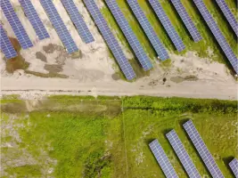
Solar Farm Layouts
Details
- Year established: 2005
Highlights and features
- We offer over 35 years of combined surveying experience since 1985.
- Our team provides advanced geospatial solutions using LiDAR and photogrammetry.
- We operate in five states with multi-jurisdictional project expertise.
- Our services support full project lifecycles from site acquisition to as-builts.
- We maintain strict adherence to North Carolina's professional surveying standards.
Services
ALTA/NSPS Surveys
We conduct ALTA/NSPS land title surveys to meet national standards for commercial real estate transactions. Our surveys identify property boundaries, easements, and improvements with high accuracy. Clients receive detailed documentation for title insurance and development planning.
3D Laser Scanning
Our 3D laser scanning creates precise point cloud models for construction and industrial sites. This technology captures millions of data points to generate as-built documentation and digital twins. Clients use these models for design validation and facility management.
Construction Staking
We provide construction staking services to accurately position buildings and infrastructure. Our team uses robotic total stations and GPS for layout precision. Contractors rely on our staking to maintain compliance with design plans and zoning regulations.
Questions
What geographic areas do you serve?
We provide surveying services in North Carolina, South Carolina, Virginia, Delaware, and West Virginia, with joint-venture capabilities in additional states.
What types of surveying projects do you specialize in?
Our specialties include commercial, industrial, boundary, topographic, construction, subdivision, and mapping projects using advanced geospatial technologies.
How do you ensure survey accuracy?
We use robotic total stations, LiDAR, photogrammetry, and GPS systems calibrated to industry standards for precise data collection and analysis.
Can you handle multi-state projects?
Yes, we hold professional registrations in five states and routinely collaborate on joint-venture projects across the United States.