Business Details
39 Years
experience
Expert Land Surveying Services in Boulder, CO
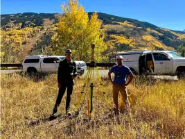
Boulder Land Consultants has provided expert land surveying and mapping services for 34 years across Boulder County and Colorado. Our team includes two licensed professional land surveyors with over 50 years of combined experience, utilizing high-precision GPS and robotic surveying technology. We serve government agencies like the City of Boulder and State of Colorado, as well as commercial and private clients, offering boundary surveys, topographic mapping, and ALTA/NSPS land title surveys.Our commitment to responsive client service and quality deliverables is supported by advanced digital tools, including AutoCAD Civil 3-D and UAV (drone) technology for aerial mapping. Recognized for excellence, our team has received awards from the Professional Land Surveyors of Colorado and maintains licenses in Colorado, Wyoming, and North Carolina.

Services
ALTA/NSPS Surveys
Boundary Surveys
Topographic Mapping
GPS Surveying
Elevation Certificates
Details
- Year established: 1987
Highlights and features
- 34 years of experience in land surveying across Colorado
- Two licensed surveyors with 50+ years combined expertise
- Advanced GPS and UAV technology for accurate mapping
- Served government agencies like the State of Colorado
- Award-winning team recognized by Professional Land Surveyors of Colorado
Services
ALTA/NSPS Surveys
ALTA/NSPS Surveys meet national standards for commercial property transactions. These detailed maps document boundary lines, easements, and improvements, ensuring compliance with title insurance requirements. Our team uses rigorous title document reviews and precise field measurements to deliver accurate surveys for out-of-state financing projects.
Boundary Surveys
Boundary Surveys determine property lines by analyzing legal descriptions and deed information. We recover monuments, perform precise measurements, and resolve conflicts between field data and title documents. Our plats include easements and encumbrances, with corner markers set for clear property delineation.
Topographic Mapping
Topographic Mapping captures land features like slopes, contours, and drainage patterns. These surveys aid architects and planners in designing infrastructure projects. We use advanced GPS and aerial technology to create detailed maps showing existing improvements and natural terrain characteristics.
GPS Surveying
GPS Surveying establishes high-accuracy control networks for large projects. Our Trimble VRS receivers and software enable precise data collection in inaccessible areas. This technology supports construction layout, utility mapping, and topographic enhancement with real-time kinematic positioning.
Elevation Certificates
Elevation Certificates verify flood risk for properties in hazard zones. We document structure elevations relative to FEMA benchmarks, helping property owners secure flood insurance. Our surveys use federally recognized benchmarks to ensure regulatory compliance for local and federal authorities.
People
Kayce D. W. Keane
President
Licensed in Colorado, Wyoming, and North Carolina, Kayce holds a Master of Science in Geographic Information Science. She has led boundary surveys, mineral surveys, and ALTA/NSPS projects since 2007. Recognized as Surveyor of the Year in 2020, she contributes to industry publications and professional organizations.
Jason Emery
Senior Land Surveyor
A licensed surveyor since 1983, Jason founded BLC in 1987 and served as Boulder County Surveyor for 12 years. He specializes in legal matters related to land surveying and provides educational presentations to realtors and title insurance professionals.
Terry Pickering
Project Manager
Licensed in Colorado since 2013, Terry has 20+ years of experience in boundary analysis and project management. He trains new employees and handles complex surveys ranging from residential to government projects, combining field and office expertise.
Curtis Klopfer
Junior Project Manager
A University of Colorado graduate, Curtis works on ALTA surveys and mineral claims while pursuing his professional license. He contributes to construction quality control and subdivision plats, applying GIS expertise to enhance surveying workflows.
John Craig
Crew Chief
With a background in psychology and criminology, Jack transitioned to land surveying after relocating from Maryland. He serves as a survey technician, applying his analytical skills to field data collection while pursuing professional licensure.
Questions
What services does Boulder Land Consultants offer?
We provide ALTA/NSPS surveys, boundary surveys, topographic mapping, GPS surveying, elevation certificates, and specialized services like mineral surveys and construction layout.
How long has BLC been in business?
Boulder Land Consultants has served clients since 1987, with 34 years of experience in land surveying across Colorado.
Do you serve mountain communities?
Yes, we work in Vail, Estes Park, Gilpin County, Eagle County, Summit County, and other Colorado mountain areas.
What technology do you use?
We utilize high-precision GPS, robotic total stations, UAV (drone) mapping, and AutoCAD Civil 3-D software for accurate surveying results.
Are your surveyors licensed?
Yes, our team includes licensed professionals in Colorado, Wyoming, and North Carolina with over 50 years of combined experience.
Who are your typical clients?
We serve government agencies like the City of Boulder, commercial developers, private property owners, and engineering firms.