Business Details
24 Years
experience
Your Trusted Land Surveying Partner in Edmond, OK
Founded in 2002 by Tracy Jividen and now led by his son Spencer Jividen, our firm represents a third generation of professional land surveyors in Oklahoma. With over 60 years of combined experience, we deliver accurate and reliable surveying solutions tailored to meet diverse client needs. Our family-owned business prioritizes trust, integrity, and personalized service in every project engagement. We specialize in boundary surveys, ALTA/NSPS title surveys, topographical mapping, and design surveys using advanced technologies. Our team maintains deep expertise in subdivision design, GPS horizontal/vertical control, and legal easement descriptions.Headquartered in Edmond, Oklahoma, we serve clients across the state with precision-driven services. Spencer Jividen, our owner and registered land surveyor, brings over 20 years of field experience managing complex surveying projects. We remain committed to continuing education and technological advancements to ensure superior service quality. Our comprehensive offerings include construction staking, elevation certificates, and telecommunication site surveys. By combining generational knowledge with modern methodologies, we uphold our legacy as Oklahoma's trusted surveying partner.
Services
Boundary Surveys
ALTA/NSPS Surveys
Topographical Mapping
Subdivision Design
Elevation Certificates
Construction Staking
GPS Control Surveys
Legal Descriptions
Telecom Site Surveys
Pipeline Surveys
Details
- Year established: 2002
Highlights and features
- Family-owned business with third-generation surveying expertise since 2002
- 60+ years combined experience in Oklahoma land surveying
- Registered professionals using advanced GPS and mapping technologies
- Comprehensive services covering all survey types from boundary to design
- Personalized approach with direct project management from senior surveyors
Services
ALTA/NSPS Surveys
Our ALTA/NSPS standard surveys provide comprehensive property documentation for real estate transactions. These detailed assessments include boundary verification, easements, and improvements to meet lender requirements. Our team follows the latest NSPS guidelines to ensure accuracy for commercial property transfers.
Topographical Mapping
We create detailed topographic surveys showing elevation changes, natural features, and man-made structures. These 3D representations support construction planning and drainage analysis. Our digital mapping integrates with CAD systems for engineering applications.
Boundary Surveys
Our certified boundary surveys establish precise property lines through historical research and field measurements. We identify encroachments and prepare legal descriptions for land transactions. This service includes monumentation of corners and preparation of surveyor's notes.
Subdivision Design
We provide complete subdivision layout services including plat preparation and municipal compliance. Our designs incorporate road access, utility easements, and lot configurations. We coordinate with local jurisdictions to ensure approval readiness for residential and commercial developments.
Construction Staking
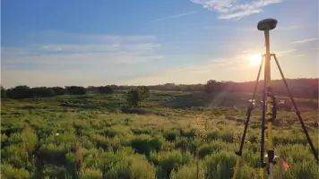
Our staking services translate design plans into physical markers for construction projects. We establish reference points for buildings, roads, and utilities using GPS and robotic total stations. This ensures accurate implementation of engineering designs during development.
People
Spencer Jividen
Owner and Manager
Registered Land Surveyor with PLS 1904 license, Spencer manages daily operations and field crews. With 20+ years experience, he specializes in ALTA surveys and construction staking. Holds Associate's Degree in Civil Surveying Technology from OSU-OKC.
Tracy Jividen
Founder
Established Jividen in 2002 as third-generation surveyor. Built reputation for precision in Oklahoma land surveys. Transferred leadership to son Spencer while maintaining advisory role in complex projects.
Questions
What survey types do you specialize in?
We specialize in ALTA/NSPS title surveys, boundary surveys, topographical mapping, subdivision design, and construction staking. Our services cover residential, commercial, and infrastructure projects across Oklahoma.
Are you licensed Oklahoma surveyors?
Yes, our team includes registered professional land surveyors licensed by the Oklahoma State Board of Registration. We maintain current certifications and continuing education requirements.
How long does a typical survey take?
Project duration varies by complexity. Boundary surveys typically take 1-2 weeks including research and fieldwork. Larger projects like subdivisions require 3-6 weeks depending on site conditions and municipal review timelines.
Do you provide digital survey deliverables?
Yes, we deliver digital files in CAD and PDF formats. Our computerized mapping integrates with engineering software. We also provide paper copies and coordinate with your design team's preferred file formats.
Can you handle emergency survey requests?
While we don't offer 24/7 emergency services, we prioritize urgent projects during regular business hours. Contact us directly to discuss time-sensitive survey requirements and availability.